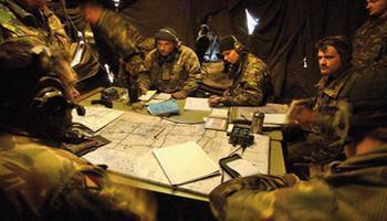


Welcome to the Defence Geographic Centre (DGC) post for the "Day of Geography" which will provide an insight into how geographers support the UK Ministry of Defence and the wider interests of the UK Government. It is by necessity quite a long post but I hope you will find it interesting and stay with me until the end. It begins with a general description of the organsation before leading into a “Day in the life of” tour. The picture shows DGC products being used for battle planning in a military Battle Group Headquarters.
DGC is a complex organisation, unique within the UK and recognised by national and international partners as world class leaders in many of our areas of operation. I am the Head of Geographic Research and my group comprises about 100 people spread across four teams. Earlier today I walked around my teams and the other parts of DGC to capture a snapshot of some of the activities on a typical day. I have also added a few details about my own activities. But first I need to set out some context; without it the day in the life snapshot will not make much sense!
DGC is based in West London and is an organisation within the Joint Forces Command of the UK Ministry of Defence. The majority of our 340 civilian personnel are members of the Geospatial Analyst specialist professional group. Director DGC is our Head of Profession. Our Geospatial Analysts are professionals in disciplines including cartography, geography, geographic information management, geopolitics, photogrammetry, imagery exploitation, aeronautical information, GIS, reprographic services, and the management and delivery of map supply.
Within DGC are a small number of military personnel from the Army's 42 Royal Engineer (Geographic) Regiment, specialists in the provision of deployable geospatial analyst support. They provide a specialist military perspective in our decisions on how to satisfy military requirements and support engagement with our customers; these include colleagues from their regiment who are attached to a variety of military units and headquarters and a larger number who remain in the regiments main base until they are called upon to deploy in support of military operations in several locations around the world.
Also closely related to DGC are specialists in air navigation/air cartography within No1 Aeronautical Documents Unit, Royal Air Force, and Royal Navy officers who are specialists in hydrography and meteorology, each responsible for managing the UK MOD relationships with the UK Hydrographic Office and Meteorological Office.
We take our professional development very seriously. Many of our people are graduates in geography and other relevant subjects, but this is not a pre-requisite for DGC recruitment. We nevertheless believe that we are the single largest employer of geographers in the UK. Some of our people have completed postgraduate qualifications in a variety of relevant subjects, often supported by DGC sponsorship. A growing number of us are also achieving Chartered Geographer accreditation with the Royal Geographical Society; this recognition of our status as professional geographers is very important to us.
Our job is to provide geographic information, advice, products and services to the MOD and HM Armed Forces. We can be called upon to provide this for any part of the world where there is a defence interest (for UK areas we use data provided by the relevant civilian national mapping authorities in Great Britain and Northern Ireland). We support every level of defence activity. But no-one else in HM Government does what we do; we are in so many ways a national asset and we therefore increasingly support other government departments through a variety of arrangements.
You can read more general background information about DGC on the www.gov.uk website:
About the Defence Geographic Centre
Putting the Military on the Map - 3 January 2013
DGC Receives GIS Award - 4 October 2012
But before you do that please consider reading on to see what is happening in DGC today……..
MONDAY 17 NOVEMBER 2014
My day started with a review of last weeks activities and a look ahead to the coming week. Every Monday my colleagues on the senior leadership team and our key team members meet to conduct a structured review of ongoing and emerging operational tasks. This is called the Monday Operations Meeting. To prepare for this I first held a short informal meeting with my own team leaders to discuss: how are things going; what has been completed and what is in progress; are there any issues that I need to be aware of; here are some things that you need to know about for the coming week potential changes in priorities, management interventions, incoming and outgoing visits; and finally a little bit of admin.
We then all joined the Monday Operations Meeting. We were briefed on latest developments and directions/requirements and my colleagues and I each provided a brief situation report on the tasks and developments in our teams. Some new urgent requirements emerged, some priorities were changed, and during the course of today I will be taking actions to adjust our response. The variety of tasks and areas of interest is huge and constantly changing. We are acquiring, producing and providing geographic information for many locations around the world – wherever there is a HM Government or MOD focus on emerging or ongoing events and crises – as well as for military training and exercises.
Everything happens somewhere and our decision makers at all levels want to know where that is, what is there, and so on.
We broadly have two types of work: our first priority is always to support the current operational and planning requirements of the MOD Permanent Joint Headquarters, as directed by the tasking authorities in Joint Forces Command. However, in order to be able to respond quickly as situations evolve (often with as little as two hours notice) we need to have anticipated and prepared as much as possible this is our longer term planned and programmed work.
After the Monday Operations Meeting we dispersed and, in order to produce the snapshot for this post, I started this special “Day of Geography tour around the DGC to see what is going on in more detail.
My first stop was with DGC's Head of Geographic Information Collection and International Relationships; he is one of my colleagues on the senior leadership team. He is researching the history of USA/UK geospatial cooperation for Defence purposes and has discovered that the very first agreement to exchange maps and survey information was signed in May 1942. There have been many agreements signed since then which have deepened the level of cooperation between the two countries. He has made a number of decisions and sent emails covering the release of UK-produced mapping and data to support the relief effort for the Ebola crisis. The aim is to allow access to vital mapping over Sierra Leone to those organisations that really need it.
My next stop is with the Geographic Applications Branch which provides technical support for our specialist geospatial tools and advises some of our customers. They are part of a group led by another of my senior leadership team colleagues who has responsibility for foundation data production, stewardship, and cartographic expertise. One of the team has recently visited Friedrichshafen to provide geographic expert support to the MOD team involved in the Airbus A400M Atlas programme. The trials involved loading and testing a number of DGC geographic datasets including raster Map data, flight obstructions data and elevation models, and this is now being followed up in the office today.
My next stop is with DGC's Senior Geographic Data Steward. Good authoritative data, and in particular its management and stewardship, is critical for DGC and the users of DGC's services. Her team is finalising the DGC Archiving and File Naming Convention Policy in support of our transformation to a Data Centric Working model. They are also finalising the report and recommendations from the Data Centric Working Pilot Study we conducted during the summer in partnership with ESRI UK and Raytheon and auditing our data repositories to ensure that we are able to prepare the data for a new approach to storage and discovery. This includes ensuring that the metadata is captured and stored in compliance with the MOD Geospatial Metadata Profile.
Next on the tour is a task team which specialises in imagery management and exploitation. They are researching commercial satellite imagery holdings to identify imagery that will be suitable for use as a source for the creation of products to support the personnel deployed to West Africa as part of the Ebola crisis response. The task team is going to rectify, reformat and enhance the imagery so that it can be exploited by the other task teams. Although the resultant products are initially aimed at the needs of UK personnel, they will almost certainly be shared with key partners.
The next task team specialises in information important to users in the aeronautical community, such as powerlines and vertical obstructions; they acquire and manage that data and ensure that it is accurately incorporated into a variety of products. This complements and supports the work of the No1 Air Information Documents Unit, which produces specialist products such as aeronautical navigation charts and documents describing the terminal approach procedures and plans for airfields. Today the task team are looking at how they can grow their capacity through cross training, so that team members can take on a wider range of activities. The work has a highly temporal nature as the outputs must support the refresh and reissue of critical flight safety outputs on a 28 day cycle. This cycle is non-negotiable and cross-training will improve the teams resilience, but it is crucial to maintain a high level of data quality at the same time.
The next segment of my tour takes in some of my own teams. My first stop is with one of my senior staff who leads the core team of geographic research experts. He has reviewed and discussed some materials from the geographical names, boundaries, and geodesy sections which will soon be used for briefing visitors to DGC. He has also held a meeting with DGC's web services team to discuss structure of the database schema for a planned MOD gazetteer to support search and discovery of information using web services. Team leadership carries additional management responsibilities and he is now assessing applications arising from a recent external recruitment campaign.
DGC's boundaries expert is one of several staff who have completed a relevant MA at Kings College London, sponsored by DGC. He started the day with a review of the daily feeds from BBC Monitoring; he was looking for news reports that might be relevant to his research into boundary issues and extracted information for reference in our digital filing system. For the remainder of the day he is writing up summaries of his research into the status and alignments of the international boundaries of a country in Africa, including factors that are relevant to understanding interstate disputes.
DGC's geographical names experts work closely with colleagues at the Permanent Committee on Geographical Names (PCGN) based at the Royal Geographical Society. Today one of the team is finalising checks on the spelling and positioning of geographical names on products to support the Ebola crisis response over West Africa. Using additional larger-scale mapping sources she has been able add names for rivers which would have otherwise remained unidentified. This will enhance the utility of the products. I called the PCGN and learned that today they are identifying the locations of villages in an African country, checking the names on another product to support the Ebola crisis response, researching names for use on briefing maps of three countries in the Middle East and Asia, and looking for new information on recent changes to internal administrative boundaries in a country in Asia.
Just around the corner one of DGC's experts in geodesy is compiling geodetic information for a new training area map so that it can include the correct magnetic information. He also has work in progress to determine the history of a map of an African country; this will enable us to accurately georeference it so that it becomes a useful source for deriving the alignments of internal administrative boundaries in that country.
I am fortunate to have a team member who has a particularly deep passion for, and expertise in, military cartography and relevant aspects of imagery exploitation. He is working on a draft specification for a new product intended to depict border porosity. He needs to include advice on the factors and potential sources (imagery and documentary sources) that should be considered, so he is conducting research into the relevance and weighting of those factors as applied to the question of what makes a border porous for determined, opportunist and encumbered groups. He will then need to devise a way to portray that porosity in a graphical form that is both meaningful and useful to the user of the product.
Anyone familiar with maps will be aware that there is a great deal of information around the margins, including the identification of the product and producer. One of my team members is an expert in these matters, as well as an expert cartographer. Today he has attended a cross-DGC daily task management meeting, before determining the product identification and marginalia guidance for two new products over a key UK naval base. His next task is to review the marginalia and cartographic content of the latest in a series of interactive geographic research products of a country in Africa.
My next stop is one of the three task teams in my group, each of which has a distinct primary expertise, but is also capable of surging support to other tasks as required. They are compiling a Map Book as part of the Ebola crisis response. It will bring together a wide variety of relatively small-scale briefing maps which have been completed across the DGC and by our team members embedded into other parts of MOD. The bundling of products produced in different places, at different times, for different purposes, inevitably highlights some inconsistencies which may reduce the users confidence in the Map Book. The team are using Adobe Photoshop to make minor adjustments so that the Map Book complies with the latest cartographic and marginalia specification.
The team have other tasks in work for another area in which MOD has personnel on the ground and is using ESRI ArcMap and imagery sources to digitise and symbolise vector data of transportation networks and buildings of interest. The vectors will be integrated with an imagery base, grid and geodetic information to form an image-map atlas. The process of defining page extents and index pages will be complex but is essential if the product is to be delivered in a format that is easy to carry and use.
One of my three task teams specialises in research-heavy products which include an element of information discovery, analysis and fusion that is more complex than that required for a typical standard specification cartographic product. The team is also developing our ability to acquire and visualise information relevant to the study of human geography. Understanding the distribution and characteristics of populations (and their relationships with the physical environment, infrastructure, economy, institutions and governance) is now accepted as essential to anticipating and responding to conflict situations, humanitarian crises and natural disasters.
The team is busy producing a range of products in support of MOD and HM Government planning and operations in many locations in Africa and the Middle East. They are also engaged in an important collaborative project with international partners to develop a structured data model to support the collection and analysis of human geography data.
I have a particular interest in the human geography developments as I chair the UK MOD Human Domain Community of Interest. Linked to this I chair an annual conference which my team and I co-organise with international partners, hosted by the DefenceAcademy at Shrivenham. The next conference will be held 1-3 June 2015 and you will be able find out more about it on the DefenceAcademy website early in 2015 by searching for Spatial Socio Cultural Knowledge Workshop. It will focus on Defence Engagement. You can read about the last conference here:
Human Geography Conference 2014
The third of my task teams is working in partnership with other DGC task teams to rapidly produce new topographic maps to military specifications for several areas of topical MOD and HM Government interest. These maps are not being compiled from scratch (which would take many weeks or months) but from a ready-made database of centre-line vector data. This is the result of several years of work by 29 nations, working in partnership to create a database of features from imagery sources to an accuracy equivalent to a 1:50,000 scale. The database is not optimised for direct use as it is intended to be the source for derived products, produced quickly (sometimes enhanced with extra content) when required. The products are then shared with key partners. DGC is one of the lead nations in this partnership led by the USA. DGC has a team dedicated to delivering our contribution which we achieve though contracts with industry partners in the commercial sector.
Elsewhere in DGC, there are small teams engaging directly with our customers to ensure that they are receiving the support they need.
We have a very small number of staff who are following up the applications from our recent external recruitment campaign; this important activity has temporarily drawn them away from their other key function of ensuring that we develop and maintain our professional skills.
We have small teams which are busy making contact with partners and suppliers all over the world to negotiate access to, or purchase of, maps and databases; these are received in paper and digital formats and, after an initial assessment to determine their usefulness, they are catalogued into our extensive libraries. The products which are judged to be suitable to satisfy high priority customer requirements are immediately diverted into the relevant parts of DGC to be exploited or passed directly to the customers in a suitable format.
In the dissemination group there is a small team maintaining MODs geographic information web services. They are working closely with a task team which is dedicated to the selection and organisation of the products and data that is judged to be most useful and suitable at a variety of scales and resolutions over countries of particular interest, so that customers can be given the best available data in a single large package on high capacity disk drives and through web services. Their colleagues nearby are extracting digital data and products in smaller volumes onto optical media and lower capacity disk drives for those customers who have more discreet requirements. For the customers who need paper maps and charts, our team is busy conducting the rapid plotting or high volume lithographic printing of quantities of maps and charts which are subsequently distributed from our map depot.
None of this would be possible without the support of our very small and dedicated team of administrative support staff.
That concludes this Day of Geography tour of the DGC. I hope that you have found it interesting to have an insight into some of the many ways in which geographers contribute to activities of national and international importance.
(c) Crown Copyright 2014