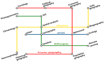


This ‘geography subway map’, like any map, should not be read literally. This is only an illustration of the complex journey one would take to travel the geographies. Source: Helene Draux.
I entered geography with a scientific bias, taking courses that were meant for us to answers to many technical questions. How do we measure the Earth? How do we model it with aerial or ground photographs? How do we represent it on a piece of paper? How do we generalize complex road networks to fit them on paper maps? How do we use tools to represent them? How do we recognize what is on the ground from a photo? How do we program earth-representation related issues? Or even how do we model the distribution and transport of goods and resources, or industrial processes?
I found the course very interesting, and I felt it was a subject I would be happy to work in, but I felt that still, something was missing. What was the point in doing all that theory if I could not apply it to the real world? The one with people in it. After two years of studies, I found an opportunity to take an MSc in the UK to explore the applications of these techniques into land management. Up until now I had studied complex mathematical and physical theories that I had mainly applied into the representation of reality on paper be it cartographic maps, photographs, or even the Internet. I thought that applied science was going to so easy, I just needed to turn the tools I had already learn to a different subject.
It turned out that I had stepped into a totally different field. From dry, scientific rigor, I jumped into environmental geography, where intellectual processes and concepts had more importance. This is not to say that environmental geography is not rigorous, or that geographic science does not have intellectual processes and concepts this was just the way I perceive the fields that are personal to me. From the fundamentals, I learned theories I had never come across before. The scientific description of earth was not as important anymore, but my ability to synthesize theories and critically engage with the literature became the focus of my days. Who said what, why, and the implications for my case study were all that mattered. My only advantage over my peers during the course was that I knew how to use tools and software that others were discovering.
This was an interesting year for me, but I nonetheless went back to my country, and started working in the national cartographic agency. I was given the task of selling and advising organizations and individuals to use cartographic data. However, rather than just selling them, I was more interested in discussing how people used maps and how much more they could do with them.
When the opportunity came to move back to the UK and start a PhD in an urban research center, I took it with expectations that I would be studying something technical. However, once again I had stepped into yet another part of geography, social geography. But this time, I discovered my home. Social geography was the exact balance of what I liked, and I found myself loving the study of people and role the spatiality within their lives. I studied how people valued open spaces in a city, how people represented space onto paper, and how people balanced values of spaces in terms of social, environmental and economic benefits.
Like many jobs, none of my days are similar to another. I am currently working at the University of Copenhagen as a researcher in the landscape department. I am involved in several projects for which my primary task is to read and synthetize the literature, but my other tasks included developing a web-based cartographic application and conceptualizing relationships between smartphone users, app creators and places. A surprising amount of my time is spent in meetings with other researchers planning current projects and discussing possible future projects. So much of my future depends on the relationships I build every day, the constant need to apply for more funding while conducting research, and also the need to write scientific articles, all at the same time. Most of the time, only research time is funded the rest is in your spare time. All that, and then teaching comes on top.
What I like the most about my job is the opportunity to conduct projects from the start to the end from applying for funding for projects we or others are interested in or feel the need for, carrying out the research (often in relation with private and public organizations), analyzing the results, and presenting them to academic peers, external organizations and the general public. The research that I undertake is also mostly embedded in practical contexts, making it important to people in real-world situations, something that is particularly important to me.
One particularly interesting project I am involved in maps peoples use of marine recreation areas. These could be surfing spots, boat moorings, snorkeling areas or swimming beaches. Knowing this is fundamental to marine planning, so that the places most favored by people can be protected. It also helps us to understand why people like these places. My colleagues worked closely with public organizations to discuss which types of data would be beneficial to them, but we also discussed within our own research group the type of data would be useful to compare to existing literature.
In order to reach out to people, I developed a platform based on Google Maps. Using this system, people could add markers at the locations of places they generally use; adding information such as the frequency of use, season of use, and many other details describing their visits. This technique, related to crowdsourcing, is increasingly used. But it can only work if people can understand and read maps, something that cannot be taken for granted and can often affect the accuracy of the data.
In the end, even though I have studied a broad variety of subjects within geography, I have actually barely scratched the surface of the subject. I used to get annoyed when I said I studied geographic sciences, and people either expected me to work as a human geographer, and to know all places, rivers, and mountains of my country. There is so much more than that to a human and physical geographer! The wealth of subject and tools is one thing I love about geography we share study themes or tools, making our relationships with each other so much richer. Today I will talk crowdsourcing tools with someone who studies energy consumption and to someone else in cognitive studies about how mapping accuracy is affected by peoples perception of space. I get to meet people from different countries all the time!
If you wonder which field of geography to choose, I would say pick techniques and tools if you like talking to equations, human geography if you like talking to books, physical geography if you like theorizing environmental processes and social geography if you want to talk to people. Although of course, you can always switch later!